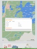


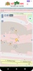


Smart Bhumi Naksha is an Android app designed to provide detailed information about plots and Mouzas through an interactive map and search features. It aims to streamline access to land management data by allowing you to view plot details, analyze land use, and access available Khatian information. Through its user-friendly interface, it facilitates quick searches and visual representations of land-related data, making it a valuable resource for effective land management.
Purpose and Core Functionality
This app is part of a broader initiative supporting a national digital land zoning project in Bangladesh. Its primary goal is to develop a comprehensive digital database of Mouza and plot-based information, ensuring efficient land management on both central and local levels. By digitizing over 138,000 Mouza map sheets, the project integrates satellite imagery and data to create georeferenced land use and zoning maps. This allows authorities and users to better plan and utilize scarce land resources.
Advantages for Users
Smart Bhumi Naksha empowers users by offering precise land use classification, helping identify different types of agricultural land. It supports sustainable land management by promoting the effective protection and utilization of agricultural resources. Additionally, the app's mapping and search capabilities are an essential tool for both field-level and centralized land management strategies, aligning with the country’s vision of digital transformation.
Smart Bhumi Naksha plays a critical role in enhancing transparency and accessibility in land management, providing a step toward more effective planning and resource optimization.
Requirements (Latest version)
- Android 5.0 or higher required
Comments
There are no opinions about Smart Bhumi Naksha yet. Be the first! Comment